


21N - Mattituck
Located in Mattituck, United States
ICAO - 21N, IATA -
Data provided by AirmateGeneral information
Coordinates: N40°59'13" W72°31'9"
Elevation is 30 feet MSL.
Magnetic variation is -14° East View others Airports in New York
Operational data
Special qualification required
Current time UTC:
Current local time:
Weather at : KFOK - Francis S Gabreski ( 19 km )
METAR: KFOK 081753Z 22009G21KT 9SM OVC004 16/15 A2961 RMK AO1 SLP028 60032 T01610150 10178 20150 55014
Communications frequencies: [VIEW]
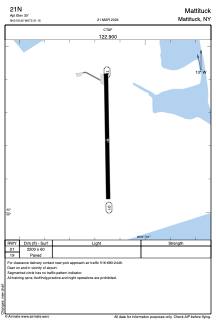
Runways:
| RWY identifier | QFU | Length (ft) | Width (ft) | Surface | LDA (ft) |
| 01 | 359° | 2200 | 60 | ASPH | |
| 19 | 179° | 2200 | 60 | ASPH |
Airport contact information
Address: Mattituck United States