


1H6 - Harvey Young
Located in Tulsa, United States
ICAO - 1H6, IATA -
Data provided by AirmateGeneral information
Coordinates: N36°8'20" W95°49'30"
Elevation is 750 feet MSL.
Magnetic variation is 06° East View others Airports in Oklahoma
Operational data
Special qualification required
Current time UTC:
Current local time:
Weather at : KTUL - Tulsa Intl ( 9 km )
METAR: KTUL 091153Z 31005KT 10SM FEW120 SCT200 13/08 A2983 RMK AO2 SLP097 T01280078 10167 20122 53022
TAF: KTUL 091120Z 0912/1012 32004KT P6SM FEW150 FEW250 FM091500 01011KT P6SM SCT150 FM100100 02005KT P6SM SKC
Communications frequencies: [VIEW]
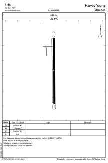
Runways:
| RWY identifier | QFU | Length (ft) | Width (ft) | Surface | LDA (ft) |
| 17 | 179° | 2580 | 40 | ASPH | |
| 35 | 359° | 2580 | 40 | ASPH | |
| N | 0° | 2580 | 80 | GRASS | |
| S | 0° | 2580 | 80 | GRASS |
Airport contact information
Address: Tulsa United States