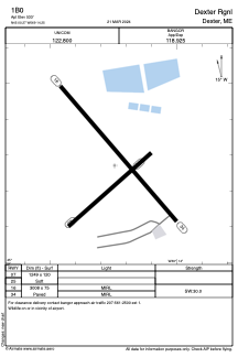


1B0 - Dexter Rgnl
Located in Dexter, United States
ICAO - 1B0, IATA -
Data provided by AirmateGeneral information
Coordinates: N45°0'16" W69°14'15"
Elevation is 533 feet MSL.
Magnetic variation is -18° East View others Airports in Maine
Operational data
Special qualification required
Current time UTC:
Current local time:
Weather at : KBGR - Bangor Intl ( 39 km )
METAR: KBGR 081853Z 17008KT 9SM -RA OVC036 12/04 A2966 RMK AO2 SLP044 P0001 T01170039
TAF: KBGR 081737Z 0818/0918 13010KT P6SM -SHRA OVC050 FM082000 12008KT 5SM -RA BR SCT015 OVC025 FM082200 09008KT 4SM -RA BR OVC015 FM090200 06006KT 3SM -RA BR OVC006 FM090900 02010KT P6SM VCSH OVC010 FM091500 02010KT P6SM VCSH BKN015 OVC025
Communications frequencies: [VIEW]
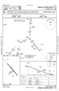
Runways:
| RWY identifier | QFU | Length (ft) | Width (ft) | Surface | LDA (ft) |
| 07 | 49° | 1249 | 120 | GRASS | |
| 25 | 229° | 1249 | 120 | GRASS | |
| 16 | 139° | 3008 | 75 | ASPH | |
| 34 | 319° | 3008 | 75 | ASPH |
Airport contact information
Address: Dexter United States