


19M - C A Moore
Located in Lexington, United States
ICAO - 19M, IATA -
Data provided by AirmateGeneral information
Coordinates: N33°7'32" W90°1'32"
Elevation is 340 feet MSL.
Magnetic variation is 02° East View others Airports in Mississippi
Operational data
Special qualification required
Current time UTC:
Current local time:
Weather at : KGWO - Greenwood-Leflore ( 41 km )
METAR: KGWO 090253Z AUTO 19007KT 10SM CLR 27/23 A2966 RMK AO2 SLP041 T02720228 53005
TAF: KGWO 082337Z 0900/0924 19010KT P6SM BKN050 FM090800 21011KT 6SM SHRA BR BKN015 OVC025 FM091300 23008KT P6SM BKN015 OVC025 FM091700 30008KT P6SM BKN050
Communications frequencies: [VIEW]
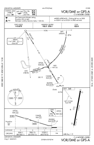
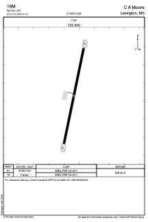
Runways:
| RWY identifier | QFU | Length (ft) | Width (ft) | Surface | LDA (ft) |
| 01 | 12° | 3199 | 60 | ASPH | |
| 19 | 192° | 3199 | 60 | ASPH |
Airport contact information
Address: Lexington United States