


18AZ - Sky Ranch At Carefree
Located in Carefree, United States
ICAO - 18AZ, IATA -
Data provided by AirmateGeneral information
Coordinates: N33°49'7" W111°53'53"
Elevation is 2569 feet MSL.
Magnetic variation is 13° East View others Airports in Arizona
Operational data
Special qualification required
Current time UTC:
Current local time:
Weather at : KSDL - Scottsdale ( 22 km )
TAF: KSDL 202337Z 2100/2124 VRB05KT P6SM SCT100 TEMPO 2100/2101 24010KT FM210400 VRB03KT P6SM SKC FM211500 16005KT P6SM SKC FM211900 23008KT P6SM SKC
Communications frequencies: [VIEW]
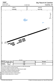
Runways:
| RWY identifier | QFU | Length (ft) | Width (ft) | Surface | LDA (ft) |
| 06 | 71° | 4029 | 50 | ASPH | |
| 24 | 251° | 4029 | 50 | ASPH |
Airport contact information
Address: Carefree United States