


16J - Dawson Muni
Located in Dawson, United States
ICAO - 16J, IATA -
Data provided by AirmateGeneral information
Coordinates: N31°44'36" W84°25'9"
Elevation is 332 feet MSL.
Magnetic variation is -02° East View others Airports in Georgia
Operational data
Special qualification required
Current time UTC:
Current local time:
Weather at : KABY - Southwest Georgia Rgnl ( 31 km )
METAR: KABY 081655Z 25007KT 10SM SCT035 SCT046 29/20 A2991 RMK AO2 T02940200
TAF: KABY 081120Z 0812/0912 22007KT P6SM BKN012 TEMPO 0812/0813 OVC007 FM081500 22010G17KT P6SM FEW250 FM090000 22007KT P6SM SCT250 FM090800 21007KT 5SM BR BKN015
Communications frequencies: [VIEW]
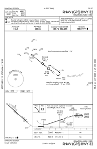
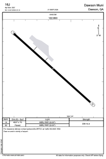
Runways:
| RWY identifier | QFU | Length (ft) | Width (ft) | Surface | LDA (ft) |
| 14 | 132° | 4507 | 75 | ASPH | |
| 32 | 312° | 4507 | 75 | ASPH |
Airport contact information
Address: Dawson United States
