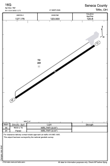


16G - Seneca County
Located in Tiffin, United States
ICAO - 16G, IATA -
Data provided by AirmateGeneral information
Coordinates: N41°5'39" W83°12'45"
Elevation is 786 feet MSL.
Magnetic variation is -05° East View others Airports in Ohio
Operational data
Special qualification required
Current time UTC:
Current local time:
Weather at : KFDY - Findlay ( 39 km )
METAR: KFDY 081853Z AUTO 27014G22KT 240V310 10SM CLR 27/07 A2973 RMK AO2 SLP060 T02670067
TAF: KFDY 081722Z 0818/0918 29012G20KT P6SM FEW250 FM082200 33006KT P6SM BKN250 FM090200 05006KT P6SM BKN090 FM090600 07012KT P6SM VCSH SCT025 OVC050 FM091500 05015G23KT 4SM -RA OVC015
Communications frequencies: [VIEW]
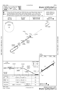
Runways:
| RWY identifier | QFU | Length (ft) | Width (ft) | Surface | LDA (ft) |
| 06 | 56° | 4000 | 75 | ASPH | |
| 24 | 236° | 4000 | 75 | ASPH |
Airport contact information
Address: Tiffin United States
