


12J - Brewton Muni
Located in Brewton, United States
ICAO - 12J, IATA -
Data provided by AirmateGeneral information
Coordinates: N31°3'3" W87°4'2"
Elevation is 99 feet MSL.
Magnetic variation is -01° East View others Airports in Alabama
Operational data
Special qualification required
Current time UTC:
Current local time:
Weather at : KNSE - Whiting Fld Nas North ( 37 km )
METAR: KNSE 091356Z 20012G20KT 10SM BKN020 BKN085 28/23 A2987 RMK AO2 SLP099 T02830233 $
TAF: TAF KNSE 0907/1007 18007KT 8000 BR SCT008 OVC015 QNH2979INS FM091200 19010KT 9999 VCSH BKN015 BKN100 OVC150 QNH2981INS FM091600 20012G22KT 6000 SHRA VCTS SCT020CB BKN030 BKN100 QNH2974INS FM100000 21010KT 9999 SCT020 BKN040 BKN180 QNH2978INS AUTOMATED SENSOR METWATCH 0907 TIL 0911 TX28/0920Z TN24/0909Z FN00273
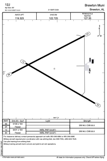
Communications frequencies: [VIEW]
Runways:
| RWY identifier | QFU | Length (ft) | Width (ft) | Surface | LDA (ft) |
| 06 | 63° | 5136 | 150 | ASPH | |
| 24 | 243° | 5136 | 150 | ASPH | |
| 12 | 120° | 5001 | 150 | ASPH | |
| 30 | 300° | 5001 | 150 | ASPH |
Airport contact information
Address: Brewton United States