


0PA3 - Robbins Farm
Located in Troy, United States
ICAO - 0PA3, IATA -
Data provided by AirmateGeneral information
Coordinates: N41°44'50" W76°45'37"
Elevation is 1455 feet MSL.
Magnetic variation is -11° East View others Airports in Pennsylvania
Operational data
Special qualification required
Current time UTC:
Current local time:
Weather at : KELM - Elmira/Corning Rgnl ( 47 km )
METAR: KELM 172253Z AUTO 20005KT 10SM OVC045 21/13 A2989 RMK AO2 SLP119 T02110128
TAF: KELM 171745Z 1718/1818 16008KT P6SM BKN060 TEMPO 1800/1803 5SM -SHRA BR OVC025 FM180300 16004KT 6SM -SHRA BR OVC025 FM180600 16004KT 5SM SHRA BR OVC015 FM181000 15004KT 5SM SHRA BR OVC008
Communications frequencies: [VIEW]
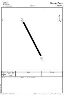
Runways:
| RWY identifier | QFU | Length (ft) | Width (ft) | Surface | LDA (ft) |
| 17 | 153° | 1977 | 100 | GRASS | |
| 35 | 333° | 1977 | 100 | GRASS |
Airport contact information
Address: Troy United States