


0KS7 - Mono Aircraft
Located in Cheney, United States
ICAO - 0KS7, IATA -
Data provided by AirmateGeneral information
Coordinates: N37°42'1" W97°53'14"
Elevation is 1510 feet MSL.
Magnetic variation is 07° East View others Airports in Kansas
Operational data
Special qualification required
Current time UTC:
Current local time:
Weather at : KICT - Wichita Dwight D Eisenhower Ntl ( 40 km )
METAR: KICT 081153Z 33011KT 10SM FEW190 FEW250 12/08 A2950 RMK AO2 SLP981 T01220083 10172 20111 53002
TAF: KICT 081123Z 0812/0912 34010KT P6SM SKC
Communications frequencies: [VIEW]
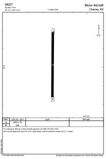
Runways:
| RWY identifier | QFU | Length (ft) | Width (ft) | Surface | LDA (ft) |
| 18 | 180° | 2000 | 75 | GRASS | |
| 36 | 360° | 2000 | 75 | GRASS |
Airport contact information
Address: Cheney United States