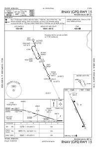


0C4 - Pender Muni
Located in Pender, United States
ICAO - 0C4, IATA -
Data provided by AirmateGeneral information
Coordinates: N42°6'48" W96°43'40"
Elevation is 1345 feet MSL.
Magnetic variation is 04° East View others Airports in Nebraska
Operational data
Special qualification required
Current time UTC:
Current local time:
Weather at : KLCG - Wayne Muni/Stan Morris Fld ( 25 km )
METAR: KLCG 081955Z AUTO 24007KT 10SM BKN080 BKN110 21/04 A2959 RMK AO2 T02070041
Communications frequencies: [VIEW]
Runways:
| RWY identifier | QFU | Length (ft) | Width (ft) | Surface | LDA (ft) |
| 15 | 155° | 3600 | 60 | CONC | |
| 33 | 335° | 3600 | 60 | CONC |
Airport contact information
Address: Pender United States