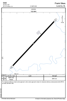


04A - Frank Sikes
Located in Luverne, United States
ICAO - 04A, IATA -
Data provided by AirmateGeneral information
Coordinates: N31°44'11" W86°15'45"
Elevation is 302 feet MSL.
Magnetic variation is -00° East View others Airports in Alabama
Operational data
Special qualification required
Current time UTC:
Current local time:
Weather at : KTOI - Troy Muni At N Kenneth Campbell Fld ( 27 km )
METAR: KTOI 091953Z AUTO 24007KT 10SM CLR 31/23 A2983 RMK AO2 SLP094 T03110228
TAF: KTOI 091729Z 0918/1018 23009KT P6SM FEW025 SCT050 BKN070 FM100400 11008KT P6SM BKN035 PROB30 1004/1010 4SM SHRA BR OVC020 FM101100 24008KT P6SM OVC010 PROB30 1015/1018 4SM SHRA BR OVC010
Communications frequencies: [VIEW]
Runways:
| RWY identifier | QFU | Length (ft) | Width (ft) | Surface | LDA (ft) |
| 04 | 43° | 4649 | 80 | ASPH | |
| 22 | 223° | 4649 | 80 | ASPH |
Airport contact information
Address: Luverne United States