


02A - Chilton County
Located in Clanton, United States
ICAO - 02A, IATA -
Data provided by AirmateGeneral information
Coordinates: N32°51'2" W86°36'41"
Elevation is 585 feet MSL.
Magnetic variation is -04° East View others Airports in Alabama
Operational data
Special qualification required
Current time UTC:
Current local time:
Weather at : KEET - Shelby County ( 40 km )
METAR: KEET 090653Z AUTO 19006KT 10SM SCT021 SCT028 OVC035 24/22 A2979 RMK AO2 SLP078 T02440222
TAF: KEET 090540Z 0906/1006 20009KT P6SM BKN025 FM091000 21007KT 5SM SHRA BR OVC013 TEMPO 0912/0916 4SM TSRA BR OVC008CB FM091800 22009KT P6SM BKN025 FM092000 24009KT P6SM BKN045 FM100100 VRB04KT P6SM SCT160
Communications frequencies: [VIEW]
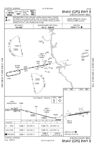
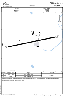
Runways:
| RWY identifier | QFU | Length (ft) | Width (ft) | Surface | LDA (ft) |
| 08 | 78° | 4007 | 100 | ASPH | |
| 26 | 258° | 4007 | 100 | ASPH |
Airport contact information
Address: Clanton United States