


YWGA - Port Hedland / Wodgina
Located in , Australia
ICAO - , IATA -
Data provided by AirmateGeneral information
Coordinates: S21°2'9" E118°38'37"
Elevation is 410 feet MSL.
View others Airports in Western Australia
Operational data
Special qualification required
Current time UTC:
Current local time:
Weather at : YPPD - Port Hedland ( 73 km )
METAR: YPPD 040730Z AUTO 12014KT 9999 // NCD 27/05 Q1018 RF00.0/000.0
TAF: TAF AMD YPPD 040522Z 0406/0506 11012KT CAVOK FM040900 12008KT CAVOK FM050000 09020G30KT CAVOK FM050400 09018KT CAVOK
Communications frequencies: [VIEW]
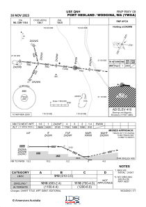
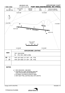
Runways:
| RWY identifier | QFU | Length (ft) | Width (ft) | Surface | LDA (ft) |
| 09 | 96° | 6890 | 98 | UNK | |
| 27 | 276° | 6890 | 98 | UNK |
Airport contact information
Address: Australia