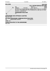


YMWA - Mullewa
Located in Mullewa, Australia
ICAO - YMWA, IATA - MXU
Data provided by AirmateGeneral information
Coordinates: S28°28'25" E115°31'4"
Elevation is 950 feet MSL.
Magnetic variation is -1° East View others Airports in Western Australia
Operational data
Special qualification required
Current time UTC:
Current local time:
Weather at : - ( 0 km )
METAR: CZUM 030538Z AUTO 09005KT 8SM RA BKN007 BKN021 BKN071 OVC098 12/12 A2999 RMK PCPN 0.8MM PAST HR SLP169
Communications frequencies: [VIEW]
Runways:
| RWY identifier | QFU | Length (ft) | Width (ft) | Surface | LDA (ft) |
| 05 | 0° | 4721 | 0 | X | |
| 23 | 0° | 4721 | 0 | X |
Airport contact information
Address: Mullewa Australia