


VVTS - Ho Chi Minh / Tan Son Nhat International
Located in Ho Chi Minh, Viet Nam
ICAO - VVTS, IATA - SGN
Data provided by AirmateGeneral information
Coordinates: N10°49'14" E106°39'39"
Elevation is 33 feet MSL.
View others Airports in Ha Tinh
Operational data
Special qualification required
Current time UTC:
Current local time:
Weather
METAR: VVTS 290530Z 30007KT 260V330 9999 FEW025 BKN060 34/25 Q1007 NOSIG
TAF: TAF VVTS 290500Z 2906/3012 29010KT 9999 SCT017 SCT040 TEMPO 2909/2913 29015G25KT 3000 TSRA BKN015 SCT017CB BKN040 TEMPO 2921/3001 5000 SHRA BKN015 FEW017CB BKN040 TEMPO 3007/3012 5000 TSRA BKN015 FEW017CB BKN040
Communications frequencies: [VIEW]
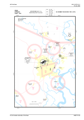
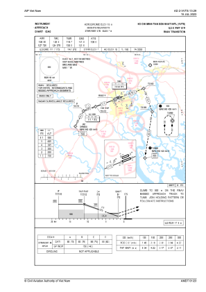
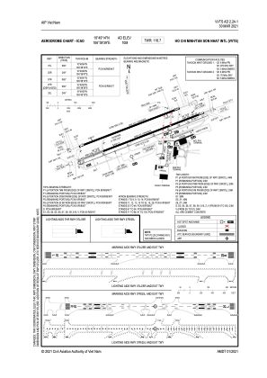
Runways:
| RWY identifier | QFU | Length (ft) | Width (ft) | Surface | LDA (ft) |
| 07L | 69° | 10007 | 148 | CON | |
| 25R | 249° | 10007 | 148 | CON | |
| 07R | 69° | 12559 | 148 | CON | |
| 25L | 249° | 12559 | 148 | CON |
Airport contact information
Address: Ho Chi Minh Viet Nam