


VERU - Rupsi Airport, Rupsi
Located in Dhubri, India
ICAO - VERU, IATA - RUP
Data provided by AirmateGeneral information
Coordinates: N26°8'25" E89°54'28"
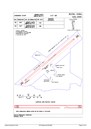
Elevation is 139 feet MSL.
View others Airports in Assam
Operational data
Special qualification required
Current time UTC:
Current local time:
Weather at : VECO - Cooch-Behar Airport ( 49 km )
METAR: VECO 291100Z 06004KT 5000 HZ SCT020 SCT025 32/31 Q0995 NOSIG
TAF: TAF VECO 290200Z 2903/2912 06005KT 3500 -RA HZ SCT018 BKN100 TEMPO 2903/2907 27015G25KT 1500 TSRA SCT015 FEW025CB OVC090 BECMG 2907/2909 13007KT
Communications frequencies: [VIEW]
Runways:
| RWY identifier | QFU | Length (ft) | Width (ft) | Surface | LDA (ft) |
| 05 | 51° | 5810 | 98 | UNK | |
| 23 | 231° | 5810 | 98 | UNK |
Airport contact information
Address: Dhubri India