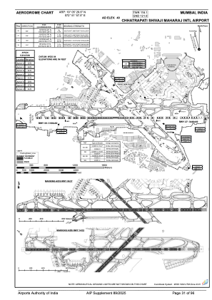


VABB - Chhatrapati Shivaji Maharaj International Airport, Mumbai
Located in Mumbai, India
ICAO - VABB, IATA - BOM
Data provided by AirmateGeneral information
Coordinates: N19°5'30" E72°51'58"
Elevation is 40 feet MSL.
View others Airports in Maharashtra
Operational data
Special qualification required
Current time UTC:
Current local time:
Weather
METAR: VABB 232300Z 21005KT 3000 BR FEW020 SCT025 30/27 Q1001 NOSIG
TAF: TAF VABB 232000Z 2321/2406 21006KT 3000 BR HZ SCT020 BECMG 2403/2405 25008KT 4000 HZ FU FEW020 SCT025
Communications frequencies: [VIEW]
Runways:
| RWY identifier | QFU | Length (ft) | Width (ft) | Surface | LDA (ft) |
| 14 | 135° | 9419 | 148 | ASP | |
| 32 | 315° | 9419 | 148 | ASP | |
| 09 | 90° | 11312 | 197 | ASP | |
| 27 | 270° | 11312 | 197 | ASP |
Airport contact information
Address: Mumbai India