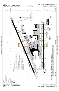


TJSJ - Luis Munoz Marin Intl
Located in San Juan, Puerto Rico
ICAO - SJU, IATA - SJU
Data provided by AirmateGeneral information
Coordinates: N18°26'22" W66°0'8"
Elevation is 10 feet MSL.
Magnetic variation is -11° East View others Airports in (unassigned)
Operational data
Special qualification required
Current time UTC:
Current local time:
Weather
METAR: TJSJ 021556Z 12006KT 9SM -RA SCT031 BKN060 BKN080 29/26 A3001 RMK AO2 RAB02 SLP161 P0001 T02890261
TAF: TJSJ 021608Z 0216/0312 10015G20KT P6SM VCTS SCT025CB BKN060 TEMPO 0216/0217 4SM -RA BKN020 OVC030 FM022200 10008KT P6SM -RA VCTS BKN030CB BKN050
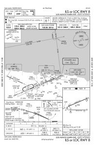
Communications frequencies: [VIEW]
Runways:
| RWY identifier | QFU | Length (ft) | Width (ft) | Surface | LDA (ft) |
| 08 | 67° | 10400 | 193 | ASPH | 9384 |
| 26 | 247° | 10400 | 193 | ASPH | 9908 |
| 10 | 90° | 8016 | 150 | CONC | 8016 |
| 28 | 270° | 8016 | 150 | CONC | 8016 |
Airport contact information
Address: San Juan Puerto Rico