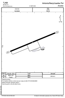


TJAB - Antonio/Nery/Juarbe Pol
Located in Arecibo, Puerto Rico
ICAO - ABO, IATA - ARE
Data provided by AirmateGeneral information
Coordinates: N18°27'3" W66°40'32"
Elevation is 21 feet MSL.
Magnetic variation is -10° East View others Airports in (unassigned)
Operational data
Special qualification required
Current time UTC:
Current local time:
Weather at : TJBQ - Rafael Hernandez ( 48 km )
METAR: TJBQ 162350Z 00000KT 10SM CLR 27/22 A2998
TAF: TJBQ 162320Z 1700/1724 10004KT P6SM FEW025 SCT035 FM171300 35007KT P6SM FEW025 FM171700 01006KT P6SM VCTS SCT025CB BKN040 FM172200 07006KT P6SM FEW025
Communications frequencies: [VIEW]
Runways:
| RWY identifier | QFU | Length (ft) | Width (ft) | Surface | LDA (ft) |
| 08 | 68° | 3964 | 60 | ASPH | |
| 26 | 248° | 3964 | 60 | ASPH |
Airport contact information
Address: Arecibo Puerto Rico