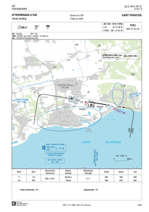


TFFC - Saint Francois
Located in Saint Francois, Guadeloupe
ICAO - TFFC, IATA - SFC
Data provided by AirmateGeneral information
Coordinates: N16°15'28" W61°15'45"
Elevation is 10 feet MSL.
Magnetic variation is -15.01° East View others Airports in (unassigned)
Operational data
Special qualification required
Current time UTC:
Current local time:
Communications frequencies: [VIEW]
Runways:
| RWY identifier | QFU | Length (ft) | Width (ft) | Surface | LDA (ft) |
| 11 | 99° | 1916 | 59 | ASPH | 1916 |
| 29 | 279° | 1916 | 59 | ASPH | 1916 |
Airport contact information
Address: Saint Francois Guadeloupe
