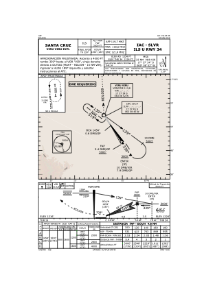
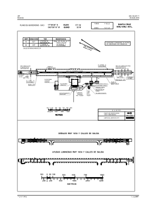


SLVR - Viru Viru/Intl
Located in Santa Cruz De La Sierra, Bolivia
ICAO - SLVR, IATA - VVI
Data provided by AirmateGeneral information
Coordinates: S17°38'46" W63°8'16"
Elevation is 1224 feet MSL.
View others Airports in Santa Cruz
Operational data
Special qualification required
Current time UTC:
Current local time:
Weather
METAR: SLVR 050900Z VRB02KT 9999 NSC 15/15 Q1015
TAF: TAF SLVR 050400Z 0506/0606 34006KT 9999 NSC TX30/0519Z TN16/0511Z TEMPO 0508/0511 SCT010 SCT070 BECMG 0514/0516 34015G25KT BECMG 0522/0601 34010KT 8000
Communications frequencies: [VIEW]
Runways:
| RWY identifier | QFU | Length (ft) | Width (ft) | Surface | LDA (ft) |
| 16 | 147° | 11483 | 148 | CON | |
| 34 | 327° | 11483 | 148 | CON |
Airport contact information
Address: Santa Cruz De La Sierra Bolivia