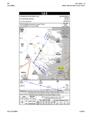


SKEJ - Yariguies
Located in Barrancabermeja, Colombia
ICAO - SKEJ, IATA - EJA
Data provided by AirmateGeneral information
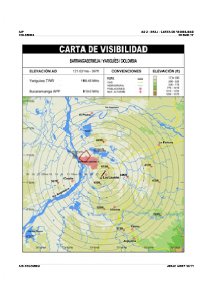
Coordinates: N7°1'26" W73°48'26"
Elevation is 414 feet MSL.
Magnetic variation is -8° East View others Airports in Santander
Operational data
Special qualification required
Current time UTC:
Current local time:
Weather at : SKBG - Palonegro ( 70 km )
METAR: SKBG 141100Z 18003KT 5000 1000S BCFG BKN006 20/20 Q1016
TAF: TAF SKBG 141030Z 1412/1512 VRB02KT 3000 BR BKN010 BECMG 1413/1415 9999 NSW SCT015 TEMPO 1413/1416 DZ BECMG 1415/1417 32011KT SCT015 TEMPO 1423/1502 RA BKN012TCU BECMG 1502/1504 VRB02KT TEMPO 1508/1512 5000 BCFG DZ BKN008 TX28/1419Z TN19/1510Z
Communications frequencies: [VIEW]
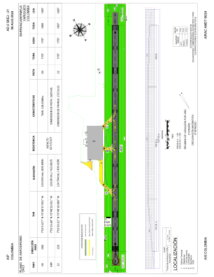
Runways:
| RWY identifier | QFU | Length (ft) | Width (ft) | Surface | LDA (ft) |
| 04 | 31° | 5906 | 148 | ASPH | 5906 |
| 22 | 211° | 5906 | 148 | ASPH | 5906 |
Airport contact information
Address: Barrancabermeja Colombia