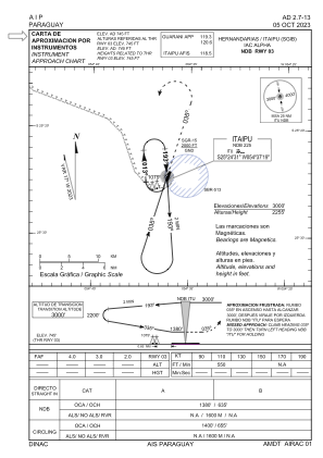
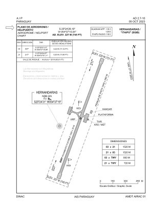


SGIB - Itaipu
Located in Hernandarias, Paraguay
ICAO - SGIB, IATA -
Data provided by AirmateGeneral information
Coordinates: S25°24'28" W54°37'10"
Elevation is 745 feet MSL.
Magnetic variation is -17° East View others Airports in Alto Paraná Department
Operational data
Special qualification required
Current time UTC:
Current local time:
Weather at : SGES - Minga Guazu / Guarani / Intl ( 23 km )
METAR: SGES 050300Z 13006KT CAVOK 19/18 Q1018
TAF: TAF SGES 042210Z 0500/0600 12004KT CAVOK TX27/0518Z TN17/0509Z BECMG 0502/0505 4000 BR NSC TEMPO 0507/0511 1000 FG BKN012 BECMG 0511/0514 04007KT 7000 NSC
Communications frequencies: [VIEW]
Runways:
| RWY identifier | QFU | Length (ft) | Width (ft) | Surface | LDA (ft) |
| 03 | 19° | 4968 | 96 | ASPH | |
| 21 | 199° | 4968 | 96 | ASPH |
Airport contact information
Address: Hernandarias Paraguay