


RJCK - Kushiro
Located in Kushiro, Japan
ICAO - RJCK, IATA - KUH
Data provided by AirmateGeneral information
Coordinates: N43°2'27" E144°11'35"
Elevation is 311 feet MSL.
View others Airports in Hokkaido Prefecture
Operational data
Special qualification required
Current time UTC:
Current local time:
Weather
METAR: RJCK 290100Z 35006KT 280V070 9999 FEW010 SCT015 BKN080 11/07 Q1001
TAF: TAF RJCK 282305Z 2900/3006 01010KT 9999 FEW015 BKN030 BECMG 2907/2909 20005KT BECMG 2915/2918 35004KT BECMG 2921/3000 19012KT
Communications frequencies: [VIEW]
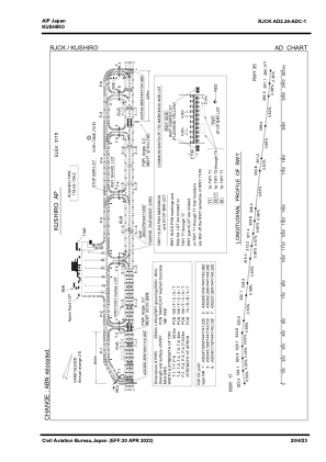
Runways:
| RWY identifier | QFU | Length (ft) | Width (ft) | Surface | LDA (ft) |
| 17 | 159° | 8202 | 148 | ASP | |
| 35 | 339° | 8202 | 148 | ASP |
Airport contact information
Address: Kushiro Japan