


P29 - Tombstone Muni
Located in Tombstone, United States
ICAO - P29, IATA -
Data provided by AirmateGeneral information
Coordinates: N31°40'17" W110°1'17"
Elevation is 4733 feet MSL.
Magnetic variation is 10° East View others Airports in Arizona
Operational data
Special qualification required
Current time UTC:
Current local time:
Weather at : KFHU - Sierra Vista Muni-Libby Aaf ( 32 km )
METAR: KFHU 080355Z AUTO 26013KT 10SM CLR 28/M05 A3003 RMK AO2 SLP093 T02841049
TAF: TAF KFHU 080400Z 0804/0910 25009KT 9999 BKN280 QNH3003INS BECMG 0812/0813 VRB06KT 9999 FEW280 QNH3007INS BECMG 0816/0817 25012G18KT 9999 SCT140 510005 QNH2997INS TEMPO 0820/0902 25015G24KT BKN140 621602 520005 BECMG 0902/0903 26012KT 9999 SCT120 QNH3001INS TX36/0821Z TN20/0812Z LAST NO AMDS AFT 0806 NEXT 1006
Communications frequencies: [VIEW]
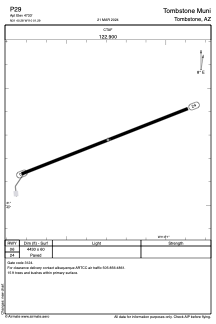
Runways:
| RWY identifier | QFU | Length (ft) | Width (ft) | Surface | LDA (ft) |
| 06 | 69° | 4430 | 60 | ASPH | |
| 24 | 249° | 4430 | 60 | ASPH |
Airport contact information
Address: Tombstone United States