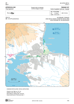


NTHV - Taravao Cht
Located in , French Polynesia
ICAO - , IATA -
Data provided by AirmateGeneral information
Coordinates: S17°43'58" W149°18'16"
Elevation is 101 feet MSL.
Magnetic variation is 13.00° East View others Airports in (unassigned)
Operational data
Special qualification required
Current time UTC:
Current local time:
Communications frequencies: [VIEW]
Runways:
Airport contact information
Address: French Polynesia