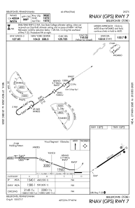
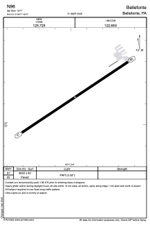


N96 - Bellefonte
Located in Bellefonte, United States
ICAO - N96, IATA -
Data provided by AirmateGeneral information
Coordinates: N40°53'8" W77°48'58"
Elevation is 1072 feet MSL.
Magnetic variation is -10° East View others Airports in Pennsylvania
Operational data
Special qualification required
Current time UTC:
Current local time:
Weather at : KUNV - State College Rgnl ( 5 km )
METAR: KUNV 011553Z 24004KT 10SM CLR 22/05 A3025
Communications frequencies: [VIEW]
Runways:
| RWY identifier | QFU | Length (ft) | Width (ft) | Surface | LDA (ft) |
| 07 | 56° | 3632 | 60 | ASPH | |
| 25 | 236° | 3632 | 60 | ASPH |
Airport contact information
Address: Bellefonte United States
