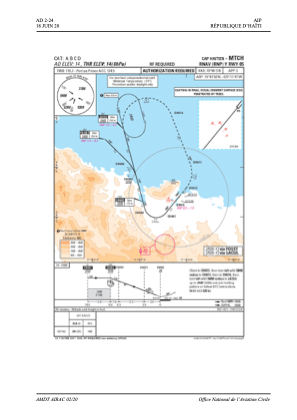


MTCH - Cap-Haitien
Located in Cap Haitien, Haiti
ICAO - MTCH, IATA - CAP
Data provided by AirmateGeneral information
Coordinates: N19°43'58" W72°11'41"
Elevation is 14 feet MSL.
View others Airports in Nord Department
Operational data
Special qualification required
Current time UTC:
Current local time:
Weather
TAF: TAF MTCH 011115Z 0112/0212 VRB02KT 9000 SCT020 TEMPO 0115/0123 04012KT 9999 SCT026 BKN040 PROB40 TEMPO 0200/0206 4800 TSRA SCT018CB BKN030 FM020800 VRB02KT 8000 SCT020
Communications frequencies: [VIEW]
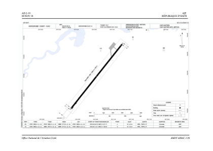
Runways:
| RWY identifier | QFU | Length (ft) | Width (ft) | Surface | LDA (ft) |
| 05 | 39° | 8701 | 148 | ASP | |
| 23 | 219° | 8701 | 148 | ASP |
Airport contact information
Address: Cap Haitien Haiti