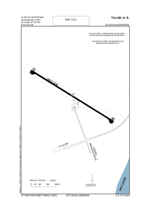


MMTU - Tulum Naval Air Station
Located in Tulum, Mexico
ICAO - MMTU, IATA - TUY
Data provided by AirmateGeneral information
Coordinates: N20°13'38" W87°26'18"
Elevation is 7 feet MSL.
Magnetic variation is -2° East View others Airports in Quintana Roo
Operational data
Special qualification required
Current time UTC:
Current local time:
Weather at : MMCZ - Cozumel Aeropuerto Internacional ( 62 km )
METAR: MMCZ 131442Z 15007KT 8SM SCT015TCU BKN250 31/27 A2984 RMK SLP112 52003 961 8/208 SC AS
TAF: TAF MMCZ 131134Z 1312/1412 13005KT P6SM SCT015 BKN250 FM131600 16010KT 5SM HZ SCT015 SCT250 TEMPO 1321/1401 5SM TSRA BKN015CB FM140100 14005KT P6SM VC RA BKN015 BKN100 BECMG 1403/1404 SCT015 SCT200 BECMG 1407/1408 3SM TSRA BKN010CB
Communications frequencies: [VIEW]
Runways:
| RWY identifier | QFU | Length (ft) | Width (ft) | Surface | LDA (ft) |
| 12 | 124° | 5862 | 82 | CONC | |
| 30 | 304° | 5862 | 82 | CONC |
Airport contact information
Address: Tulum Mexico