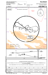
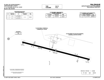


MMPQ - Palenque Aeropuerto De Palenque
Located in Palenque, Mexico
ICAO - MMPQ, IATA - PQM
Data provided by AirmateGeneral information
Coordinates: N17°31'59" W92°0'56"
Elevation is 165 feet MSL.
View others Airports in Chiapas
Operational data
Special qualification required
Current time UTC:
Current local time:
Weather
TAF: TAF AMD MMPQ 312118Z 3121/0118 09017KT 5SM HZ BKN200 TEMPO 3123/0103 12015G25KT FM010400 12008KT 6SM HZ SKC BECMG 0112/0113 3SM HZ
Communications frequencies: [VIEW]
Runways:
| RWY identifier | QFU | Length (ft) | Width (ft) | Surface | LDA (ft) |
| 10 | 105° | 8202 | 148 | UNK | |
| 28 | 285° | 8202 | 148 | UNK |
Airport contact information
Address: Palenque Mexico