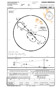
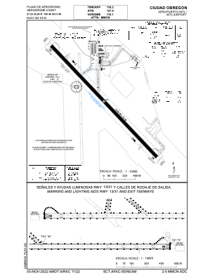


MMCN - Cd. Obregon Aeropuerto Internacional
Located in Ciudad Obregon, Mexico
ICAO - MMCN, IATA - CEN
Data provided by AirmateGeneral information
Coordinates: N27°23'34" W109°49'59"
Elevation is 205 feet MSL.
View others Airports in Sonora
Operational data
Special qualification required
Current time UTC:
Current local time:
Weather
METAR: MMCN 141756Z 21005KT 10SM SKC 34/17 A2981 RMK SLP095 HZY
TAF: TAF MMCN 141652Z 1418/1518 20010KT 6SM HZ SKC FM150400 16005KT 6SM HZ SCT020 BKN100 TEMPO 1512/1515 BKN015 FM151500 16008KT 6SM HZ SCT020
Communications frequencies: [VIEW]
Runways:
| RWY identifier | QFU | Length (ft) | Width (ft) | Surface | LDA (ft) |
| 13 | 137° | 7546 | 148 | ASP | |
| 31 | 317° | 7546 | 148 | ASP |
Airport contact information
Address: Ciudad Obregon Mexico