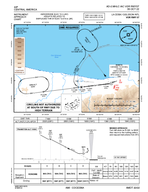
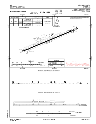


MHLC - Goloson
Located in La Ceiba, Honduras
ICAO - MHLC, IATA - LCE
Data provided by AirmateGeneral information
Coordinates: N15°44'33" W86°51'12"
Elevation is 49 feet MSL.
View others Airports in Atlantida
Operational data
Special qualification required
Current time UTC:
Current local time:
Weather
METAR: MHLC 012200Z 06015KT 040V110 9999 TS SCT030TCU SCT035CB BKN080 31/25 Q1010 A2983 NOSIG
TAF: TAF MHLC 011650Z 0118/0218 06012KT 9999 FEW030 TX34/0119Z TN24/0212Z TEMPO 0121/0201 4000 TSSHRA SCT032TCU FEW034CB BECMG 0201/0203 VRB03KT SCT032
Communications frequencies: [VIEW]
Runways:
| RWY identifier | QFU | Length (ft) | Width (ft) | Surface | LDA (ft) |
| 07 | 67° | 9675 | 148 | ASP | |
| 25 | 247° | 9675 | 148 | ASP |
Airport contact information
Address: La Ceiba Honduras