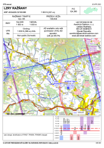


LZRY - Raznany
Located in Raznany, Slovakia
ICAO - , IATA -
Data provided by AirmateGeneral information
Coordinates: N49°4'42" E21°5'59"
Elevation is 1053 feet MSL.
Magnetic variation is 5.068° East View others Airports in Prešov
Operational data
Special qualification required
Current time UTC:
Current local time:
Weather at : LZPW - Presov ( 16 km )
TAF: TAF COR LZPW 231630Z 2318/2406 05010KT CAVOK TEMPO 2318/2320 05016KT 4000 -SHRA SCT020TCU BKN030 PROB40 TEMPO 2318/2320 02016G28KT 2500 -TSRA SCT020CB BKN030 PROB40 TEMPO 2400/2406 VRB03KT 0600 FG OVC002
Communications frequencies: [VIEW]
Runways:
| RWY identifier | QFU | Length (ft) | Width (ft) | Surface | LDA (ft) |
| 16L | 0° | 3445 | 230 | GRASS | |
| 34R | 0° | 3445 | 230 | GRASS | |
| 16R | 0° | 3445 | 98 | GRASS | |
| 34L | 0° | 3445 | 98 | GRASS |
Airport contact information
Address: Raznany Slovakia