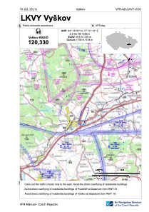
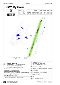


LKVY - Vyskov
Located in Vyskov, Czech Republic
ICAO - LKVY, IATA -
Data provided by AirmateGeneral information
Coordinates: N49°18'1" E17°1'31"
Elevation is 915 feet MSL.
View others Airports in South Moravian Region
Operational data
Special qualification required
Current time UTC:
Current local time:
Weather at : LKTB - Brno/Turany ( 29 km )
METAR: LKTB 231500Z 34003KT 280V090 CAVOK 22/09 Q1014 NOSIG
TAF: TAF LKTB 231100Z 2312/2412 05007KT 9999 SCT035 TEMPO 2312/2316 6000 -SHRA BKN035TCU BECMG 2404/2406 BKN020 TEMPO 2407/2412 4000 SHRA SCT012 BKN016CB PROB40 TEMPO 2409/2412 2000 TSRA BKN012CB
Communications frequencies: [VIEW]
Runways:
| RWY identifier | QFU | Length (ft) | Width (ft) | Surface | LDA (ft) |
| 02 | 0° | 4199 | 197 | UNK | |
| 20 | 0° | 4199 | 197 | UNK |
Airport contact information
Address: Vyskov Czech Republic

