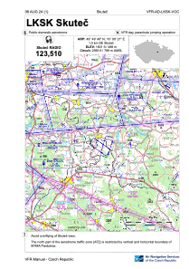


LKSK - Skutec
Located in Skutec, Czech Republic
ICAO - LKSK, IATA -
Data provided by AirmateGeneral information
Coordinates: N49°49'40" E16°0'21"
Elevation is 1601 feet MSL.
View others Airports in Pardubice Region
Operational data
Special qualification required
Current time UTC:
Current local time:
Weather at : LKPD - Pardubice ( 28 km )
TAF: TAF LKPD 062300Z 0700/0800 VRB02KT CAVOK TEMPO 0700/0705 3000 BCFG BR PROB40 TEMPO 0700/0705 0600 FG BECMG 0706/0708 29008KT SCT030
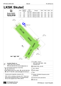
Communications frequencies: [VIEW]
Runways:
| RWY identifier | QFU | Length (ft) | Width (ft) | Surface | LDA (ft) |
| 13 | 0° | 2881 | 656 | UNK | |
| 31 | 0° | 2881 | 656 | UNK | |
| 03 | 0° | 1864 | 492 | UNK | |
| 21 | 0° | 1864 | 492 | UNK |
Airport contact information
Address: Skutec Czech Republic
