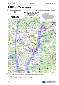
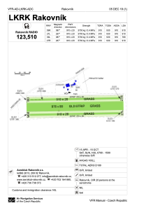


LKRK - Rakovnik
Located in Rakovnik, Czech Republic
ICAO - LKRK, IATA -
Data provided by AirmateGeneral information
Coordinates: N50°5'39" E13°41'20"
Elevation is 1273 feet MSL.
View others Airports in Central Bohemian Region
Operational data
Special qualification required
Current time UTC:
Current local time:
Weather at : LKPR - Praha/Ruzyne ( 41 km )
METAR: LKPR 041100Z 34004KT 9999 FEW030 BKN037 16/09 Q1015 NOSIG
TAF: TAF LKPR 041100Z 0412/0518 VRB02KT 9999 BKN033 BECMG 0416/0418 20007KT CAVOK TEMPO 0500/0504 5000 BR NSC TEMPO 0510/0518 -SHRA SCT035TCU PROB30 TEMPO 0513/0516 SCT035CB
Communications frequencies: [VIEW]
Runways:
| RWY identifier | QFU | Length (ft) | Width (ft) | Surface | LDA (ft) |
| 09L | 0° | 2986 | 66 | UNK | |
| 27R | 0° | 2986 | 66 | UNK | |
| 09R | 0° | 2986 | 66 | UNK | |
| 27L | 0° | 2986 | 66 | UNK |
Airport contact information
Address: Rakovnik Czech Republic