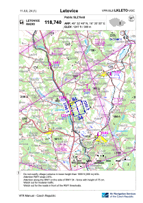
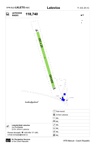


LKLETO - Letovice
Located in Letovice, Czech Republic
ICAO - , IATA -
Data provided by AirmateGeneral information
Coordinates: N49°32'48" E16°35'55"
Elevation is 1247 feet MSL.
View others Airports in South Moravian Region
Operational data
Special qualification required
Current time UTC:
Current local time:
Weather at : LKTB - Brno/Turany ( 44 km )
METAR: LKTB 041500Z 28004KT 230V340 9999 FEW033 BKN040 19/11 Q1013 NOSIG
TAF: TAF LKTB 041100Z 0412/0512 33008KT 9999 BKN030 BECMG 0412/0414 15004KT BECMG 0421/0423 VRB02KT 1600 BR SCT003 TEMPO 0423/0506 0600 FG OVC002 BECMG 0506/0508 20006KT 6000 BKN012 BECMG 0508/0510 9999 SCT012 TEMPO 0510/0512 SHRA BKN035TCU
Communications frequencies: [VIEW]
Runways:
| RWY identifier | QFU | Length (ft) | Width (ft) | Surface | LDA (ft) |
| 16 | 165° | 1476 | 66 | GRASS | 1476 |
| 34 | 345° | 1476 | 66 | GRASS | 1476 |
Airport contact information
Address: Letovice Czech Republic