


LKKOTV - Kotvrdovice
Located in Blansko, Czech Republic
ICAO - , IATA -
Data provided by AirmateGeneral information
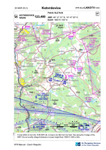
Coordinates: N49°21'51" E16°47'3"
Elevation is 1860 feet MSL.
View others Airports in South Moravian Region
Operational data
Special qualification required
Current time UTC:
Current local time:
Weather at : LKTB - Brno/Turany ( 25 km )
TAF: TAF LKTB 231100Z 2312/2412 05007KT 9999 SCT035 TEMPO 2312/2316 6000 -SHRA BKN035TCU BECMG 2404/2406 BKN020 TEMPO 2407/2412 4000 SHRA SCT012 BKN016CB PROB40 TEMPO 2409/2412 2000 TSRA BKN012CB
Communications frequencies: [VIEW]
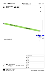
Runways:
| RWY identifier | QFU | Length (ft) | Width (ft) | Surface | LDA (ft) |
| 10 | 103° | 1509 | 66 | GRASS | 1509 |
| 28 | 283° | 1509 | 66 | GRASS | 1509 |
Airport contact information
Address: Blansko Czech Republic