


LKBYST - Bystrice
Located in Bystrice, Czech Republic
ICAO - , IATA -
Data provided by AirmateGeneral information
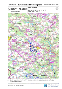
Coordinates: N49°31'22" E16°13'56"
Elevation is 1942 feet MSL.
Magnetic variation is 0° East View others Airports in Vysocina Region
Operational data
Special qualification required
Current time UTC:
Current local time:
Weather at : LKNA - Namest ( 40 km )
METAR: LKNA 230930Z 33008KT 9999 BKN026 18/10 Q1016 RMK BLACK
TAF: TAF LKNA 230500Z 2306/2406 30008KT CAVOK PROB40 TEMPO 2309/2320 23014KT 8000 SHRA BKN030TCU BECMG 2318/2320 04006KT
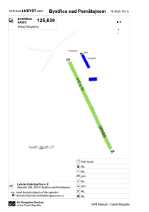
Communications frequencies: [VIEW]
Runways:
| RWY identifier | QFU | Length (ft) | Width (ft) | Surface | LDA (ft) |
| 16 | 156° | 1476 | 49 | GRASS | 1476 |
| 34 | 336° | 1476 | 49 | GRASS | 1476 |
Airport contact information
Address: Bystrice Czech Republic