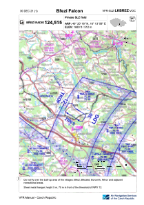


LKBREZ - Brezi
Located in Velká Bíteš, Czech Republic
ICAO - , IATA -
Data provided by AirmateGeneral information
Coordinates: N49°20'20" E16°13'52"
Elevation is 1680 feet MSL.
View others Airports in Vysocina Region
Operational data
Special qualification required
Current time UTC:
Current local time:
Weather at : LKNA - Namest ( 21 km )
METAR: LKNA 042130Z 08004KT 050V170 CAVOK 14/09 Q1014 RMK BLACK
TAF: TAF LKNA 041700Z 0418/0518 VRB02KT CAVOK TEMPO 0503/0507 2000 BR NSC PROB30 TEMPO 0503/0506 0800 FG VV002 TEMPO 0510/0515 27008KT BKN030 TEMPO 0511/0514 30012KT BKN025TCU
Communications frequencies: [VIEW]
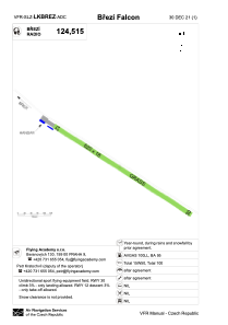
Runways:
| RWY identifier | QFU | Length (ft) | Width (ft) | Surface | LDA (ft) |
| 12 | 123° | 2034 | 59 | GRASS | 1148 |
| 30 | 303° | 2034 | 59 | GRASS | 1148 |
Airport contact information
Address: Velká Bíteš Czech Republic