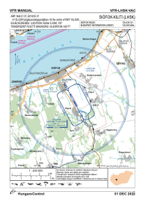


LHSK - Siofok-Kiliti
Located in Siofok, Hungary
ICAO - LHSK, IATA -
Data provided by AirmateGeneral information
Coordinates: N46°51'37" E18°5'37"
Elevation is 420 feet MSL.
View others Airports in Somogy
Operational data
Special qualification required
Current time UTC:
Current local time:
Weather at : LHPA - Papa ( 72 km )
METAR: LHPA 031745Z 03004KT 350V070 9999 SCT033TCU BKN046 BKN083 19/15 Q1011 TEMPO -SHRA RMK BLU
TAF: TAF LHPA 031715Z 0318/0418 VRB03KT 9999 SCT030 BKN045 BKN080 TEMPO 0318/0320 VRB16G30KT 5000 SHRA TSRA SCT025CB SCT030TCU BKN045 BECMG 0319/0322 9999 BKN025 OVC040 TEMPO 0320/0407 33008KT 3000 RA -SHRA BR SCT005 BKN010 OVC030 BECMG 0406/0409 33010KT PROB30 TEMPO 0407/0412 6000 -SHRA SCT015TCU BKN020 BECMG 0410/0413 9999 SCT030 BECMG 0414/0418 VRB03KT CAVOK
Communications frequencies: [VIEW]
Runways:
| RWY identifier | QFU | Length (ft) | Width (ft) | Surface | LDA (ft) |
| 15L | 0° | 4101 | 164 | GRASS | |
| 33R | 0° | 4101 | 164 | GRASS | |
| 15R | 0° | 1969 | 59 | ASPH | |
| 33L | 0° | 1969 | 59 | ASPH |
Airport contact information
Address: Siofok Hungary