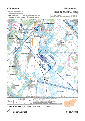
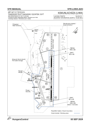


LHKK - Kiskunlachaza
Located in Kiskunlachaza, Hungary
ICAO - , IATA -
Data provided by AirmateGeneral information
Coordinates: N47°10'17" E19°4'54"
Elevation is 318 feet MSL.
View others Airports in Pest
Operational data
Special qualification required
Current time UTC:
Current local time:
Weather at : LHBP - Budapest/Liszt Ferenc International Airport ( 33 km )
METAR: LHBP 031000Z 09005KT 050V160 9999 -SHRA FEW030 BKN070 22/15 Q1014 NOSIG
TAF: TAF LHBP 030515Z 0306/0406 VRB03KT CAVOK TEMPO 0306/0312 -SHRA SCT045TCU BKN070 BECMG 0308/0310 10007KT TEMPO 0312/0317 VRB18G30KT 4000 SHRA TSRA SCT040CB BKN060 TEMPO 0317/0321 VRB25G45KT 1500 +TSRA SQ BKN010 BKN020CB BECMG 0321/0324 VRB03KT BKN015 TEMPO 0400/0406 5000 -RA BR BKN008
Communications frequencies: [VIEW]
Runways:
| RWY identifier | QFU | Length (ft) | Width (ft) | Surface | LDA (ft) |
| 13 | 0° | 2608 | 148 | CONC | |
| 31 | 0° | 2608 | 148 | CONC |
Airport contact information
Address: Kiskunlachaza Hungary