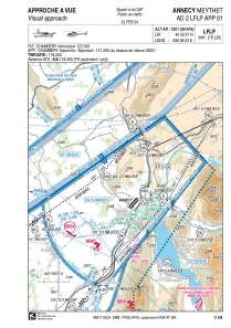

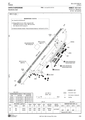


LFLP - Annecy Meythet
Located in Annecy, France
ICAO - LFLP, IATA - NCY
Data provided by AirmateGeneral information
Coordinates: N45°55'51" E6°6'23"
Elevation is 1521 feet MSL.
Magnetic variation is 2.14° East View others Airports in Rhône Alpes
Operational data
Special qualification required
Current time UTC:
Current local time:
Weather
METAR: LFLP 031630Z AUTO 20010KT 180V240 9999 BKN032/// OVC038/// ///TCU 18/15 Q1016 TEMPO 34006KT 4000 SHRA FEW025CB BKN030TCU
TAF: TAF LFLP 031400Z 0315/0415 34006KT 9999 BKN040 TEMPO 0315/0319 FEW030TCU PROB30 TEMPO 0315/0318 4000 SHRA FEW025CB BKN030TCU BECMG 0318/0320 VRB02KT PROB30 TEMPO 0403/0406 BKN006 BECMG 0409/0411 24006KT SCT030
Communications frequencies: [VIEW]
Runways:
| RWY identifier | QFU | Length (ft) | Width (ft) | Surface | LDA (ft) |
| 04 | 39° | 5348 | 98 | ASPH | 4370 |
| 22 | 219° | 5348 | 98 | ASPH | 4311 |
| 04R | 39° | 2772 | 197 | GRASS | 2028 |
| 22L | 219° | 2772 | 197 | GRASS | 2549 |
Airport contact information
Address: Annecy France


