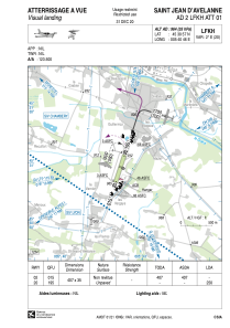


LFKH - Saint Jean D'avelanne
Located in , France
ICAO - LFKH, IATA -
Data provided by AirmateGeneral information
Coordinates: N45°30'57" E5°40'46"
Elevation is 964 feet MSL.
Magnetic variation is 2.03° East View others Airports in Rhône Alpes
Operational data
Special qualification required
Current time UTC:
Current local time:
Weather at : LFLB - Chambery Aix Les Bains ( 21 km )
METAR: LFLB 111100Z AUTO 01004KT 310V060 9999 FEW045 BKN056 BKN100 21/12 Q1013 TEMPO 4000 SHRA SCT040TCU
TAF: TAF LFLB 110800Z 1109/1209 36006KT 9999 SCT040 BKN050 PROB40 TEMPO 1109/1118 VRB05KT SCT040TCU PROB30 TEMPO 1110/1118 4000 SHRA BECMG 1118/1120 SCT050
Communications frequencies: [VIEW]
Runways:
| RWY identifier | QFU | Length (ft) | Width (ft) | Surface | LDA (ft) |
| 02 | 17° | 1335 | 115 | GRASS | |
| 20 | 197° | 1335 | 115 | GRASS | 820 |
Airport contact information
Address: France