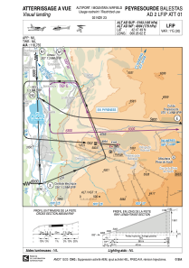


LFIP - Peyresourde Balestas
Located in , France
ICAO - LFIP, IATA -
Data provided by AirmateGeneral information
Coordinates: N42°47'49" E0°26'2"
Elevation is 5193 feet MSL.
Magnetic variation is 0.74° East View others Airports in Midi-Pyrénées
Operational data
Special qualification required
Current time UTC:
Current local time:
Communications frequencies: [VIEW]
Runways:
| RWY identifier | QFU | Length (ft) | Width (ft) | Surface | LDA (ft) |
| 09 | 94° | 1542 | 66 | ASPH | |
| 27 | 274° | 1542 | 66 | ASPH |
Airport contact information
Address: France
