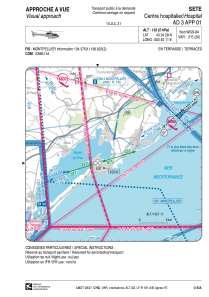


LFH456 - Sete Helistation Des Hopitaux Du Bassin De Thau
Located in , France
ICAO - , IATA -
Data provided by AirmateGeneral information
Coordinates: N43°24'28" E3°40'11"
Elevation is 132 feet MSL.
Magnetic variation is 1.56° East View others Airports in Languedoc-Roussillon
Operational data
Special qualification required
Current time UTC:
Current local time:
Weather at : LFMU - Beziers Vias ( 27 km )
METAR: LFMU 291030Z AUTO 33008KT 300V360 CAVOK 25/12 Q1016 NOSIG
Communications frequencies: [VIEW]
Runways:
Airport contact information
Address: France