


LFGU - Sarreguemines Neunkirch
Located in Sarreguemines, France
ICAO - LFGU, IATA -
Data provided by AirmateGeneral information
Coordinates: N49°7'39" E7°6'24"
Elevation is 863 feet MSL.
Magnetic variation is 2.39° East View others Airports in Lorraine
Operational data
Special qualification required
Current time UTC:
Current local time:
Weather at : EDDR - Saarbruecken ( 10 km )
METAR: EDDR 170420Z AUTO 24005KT 9999 -RA FEW006 BKN018 BKN026 14/14 Q1012 NOSIG
TAF: TAF EDDR 162300Z 1700/1724 20006KT 9999 SCT010 BKN020 PROB30 TEMPO 1700/1707 4000 RA BR BKN004 TEMPO 1709/1724 SHRA BKN014CB PROB30 TEMPO 1714/1721 22015G30KT 4000 TSRA PROB30 TEMPO 1722/1724 1000 BCFG
Communications frequencies: [VIEW]
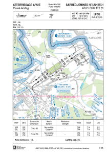
Runways:
| RWY identifier | QFU | Length (ft) | Width (ft) | Surface | LDA (ft) |
| 05R | 54° | 2343 | 262 | GRASS | 2008 |
| 23L | 234° | 2343 | 262 | GRASS | 2343 |
| 05L | 54° | 2343 | 492 | GRASS | 2343 |
| 23R | 234° | 2343 | 492 | GRASS | 2343 |
Airport contact information
Address: Sarreguemines France
Fuel provider

Other aviation service providers
Aviation club (not for profit)

Espoir Aéronautique de Sarreguemines
Espoir Aéronautique de Sarreguemines
espoir.aeronautique@lfgu.fr+33387953350