


LFDR - La Reole Floudes
Located in La Reole, France
ICAO - LFDR, IATA -
Data provided by AirmateGeneral information
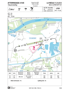
Coordinates: N44°34'1" W0°3'26"
Elevation is 44 feet MSL.
Magnetic variation is 0.54° East View others Airports in Aquitaine
Operational data
Special qualification required
Current time UTC:
Current local time:
Weather at : LFBE - Bergerac Dordogne Perigord ( 54 km )
METAR: LFBE 290830Z AUTO VRB01KT 9999 //////TCU 15/13 Q1019 BECMG BKN030
TAF: TAF LFBE 290500Z 2906/3006 VRB02KT CAVOK BECMG 2910/2912 28010KT BECMG 2909/2911 BKN030 TEMPO 2911/3006 3000 RA BKN010 PROB40 TEMPO 3000/3006 1500 RADZ BKN002 BKN005
Communications frequencies: [VIEW]
Runways:
| RWY identifier | QFU | Length (ft) | Width (ft) | Surface | LDA (ft) |
| 08 | 78° | 3156 | 197 | GRASS | 3156 |
| 26 | 258° | 3156 | 197 | GRASS | 2552 |
Airport contact information
Address: La Reole France
