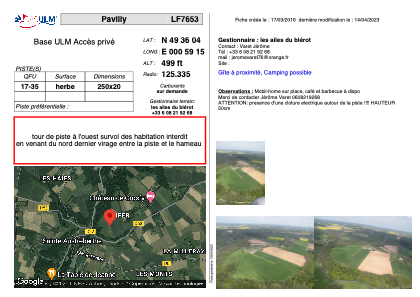


LF7653 - Pavilly
Located in Hugleville-en-Caux, France
ICAO - , IATA -
Data provided by AirmateGeneral information
Coordinates: N49°36'4" E0°59'15"
Elevation is 499 feet MSL.
View others Airports in Upper Normandy
Operational data
Special qualification required
Current time UTC:
Current local time:
Weather at : LFOP - Rouen Vallee De Seine ( 27 km )
TAF: TAF LFOP 291100Z 2912/2921 27010KT 9999 BKN020 TEMPO 2912/2920 4000 RA BKN006 OVC014 PROB40 TEMPO 2912/2918 2000 RA BKN005 OVC008
Communications frequencies: [VIEW]
Runways:
| RWY identifier | QFU | Length (ft) | Width (ft) | Surface | LDA (ft) |
| 17 | 0° | 820 | 65 | GRASS | |
| 35 | 0° | 820 | 65 | GRASS |
Airport contact information
Address: Hugleville-en-Caux France